|
|
|||||||||||||||||
| Point ID: 3088 | Downloads | Plots | Site Data | Code: 05SA004 |
|
|
|||||||||||||||||
| Download | |
|---|---|
| Site Descriptor Information | Site Time Series Data |
| Link to all available data | |
| View: | Time Series | All |
| Units: | mm |
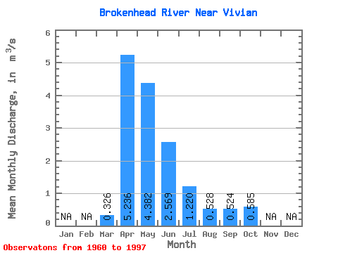
| Statistic | Jan | Feb | Mar | Apr | May | Jun | Jul | Aug | Sep | Oct | Nov | Dec | Annual |
|---|---|---|---|---|---|---|---|---|---|---|---|---|---|
| Mean | 0.33 | 5.24 | 4.38 | 2.57 | 1.22 | 0.53 | 0.52 | 0.58 | |||||
| Standard Deviation | 1.01 | 5.42 | 5.28 | 2.34 | 1.79 | 1.57 | 1.04 | 1.05 | |||||
| Min | 0.00 | 0.07 | 0.01 | 0.01 | 0.00 | 0.00 | 0.00 | 0.00 | |||||
| Max | 6.05 | 21.90 | 21.70 | 7.68 | 9.90 | 7.55 | 4.30 | 5.20 | |||||
| Coefficient of Variation | 3.09 | 1.03 | 1.21 | 0.91 | 1.47 | 2.97 | 1.99 | 1.79 |
 Return to R-Arctic Net Home Page