|
|
|||||||||||||||||
| Point ID: 3088 | Downloads | Plots | Site Data | Code: 05SA004 |
|
|
|||||||||||||||||
| Download | |
|---|---|
| Site Descriptor Information | Site Time Series Data |
| Link to all available data | |
| View: | Time Series | All |
| Units: | m3/s |
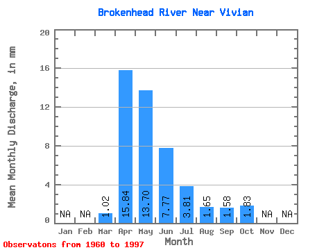
| Statistic | Jan | Feb | Mar | Apr | May | Jun | Jul | Aug | Sep | Oct | Nov | Dec | Annual |
|---|---|---|---|---|---|---|---|---|---|---|---|---|---|
| Mean | 1.02 | 15.84 | 13.69 | 7.77 | 3.81 | 1.65 | 1.58 | 1.83 | |||||
| Standard Deviation | 3.14 | 16.38 | 16.51 | 7.08 | 5.61 | 4.89 | 3.16 | 3.27 | |||||
| Min | 0.00 | 0.20 | 0.02 | 0.02 | 0.00 | 0.00 | 0.00 | 0.00 | |||||
| Max | 18.91 | 66.24 | 67.81 | 23.23 | 30.94 | 23.59 | 13.01 | 16.25 | |||||
| Coefficient of Variation | 3.09 | 1.03 | 1.21 | 0.91 | 1.47 | 2.97 | 1.99 | 1.79 |
 Return to R-Arctic Net Home Page