|
|
|||||||||||||||||
| Point ID: 3087 | Downloads | Plots | Site Data | Code: 05SA002 |
|
|
|||||||||||||||||
| Download | |
|---|---|
| Site Descriptor Information | Site Time Series Data |
| Link to all available data | |
| View: | Time Series | All |
| Units: | mm |
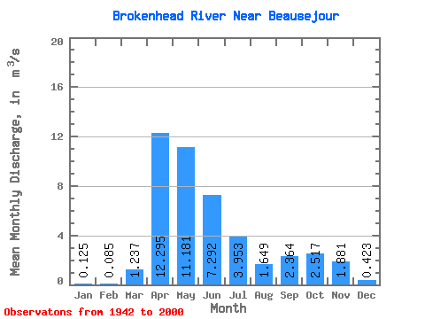
| Statistic | Jan | Feb | Mar | Apr | May | Jun | Jul | Aug | Sep | Oct | Nov | Dec | Annual |
|---|---|---|---|---|---|---|---|---|---|---|---|---|---|
| Mean | 0.12 | 0.09 | 1.24 | 12.29 | 11.18 | 7.29 | 3.95 | 1.65 | 2.36 | 2.52 | 1.88 | 0.42 | 3.56 |
| Standard Deviation | 0.12 | 0.07 | 2.22 | 11.31 | 12.28 | 6.61 | 5.26 | 3.27 | 4.25 | 4.60 | 3.08 | 0.55 | 2.61 |
| Min | 0.00 | 0.00 | 0.00 | 0.39 | 0.14 | 0.05 | 0.05 | 0.04 | 0.01 | 0.03 | 0.03 | 0.02 | 0.30 |
| Max | 0.44 | 0.32 | 13.50 | 54.10 | 53.70 | 27.80 | 35.20 | 19.80 | 18.00 | 28.10 | 13.00 | 2.63 | 10.75 |
| Coefficient of Variation | 0.95 | 0.83 | 1.80 | 0.92 | 1.10 | 0.91 | 1.33 | 1.98 | 1.80 | 1.83 | 1.64 | 1.29 | 0.73 |
 Return to R-Arctic Net Home Page