|
|
|||||||||||||||||
| Point ID: 3087 | Downloads | Plots | Site Data | Code: 05SA002 |
|
|
|||||||||||||||||
| Download | |
|---|---|
| Site Descriptor Information | Site Time Series Data |
| Link to all available data | |
| View: | Time Series | All |
| Units: | m3/s |
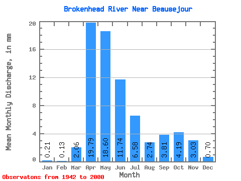
| Statistic | Jan | Feb | Mar | Apr | May | Jun | Jul | Aug | Sep | Oct | Nov | Dec | Annual |
|---|---|---|---|---|---|---|---|---|---|---|---|---|---|
| Mean | 0.21 | 0.13 | 2.06 | 19.79 | 18.60 | 11.74 | 6.58 | 2.74 | 3.81 | 4.19 | 3.03 | 0.70 | 69.75 |
| Standard Deviation | 0.20 | 0.11 | 3.70 | 18.22 | 20.43 | 10.64 | 8.75 | 5.44 | 6.84 | 7.65 | 4.96 | 0.91 | 51.10 |
| Min | 0.01 | 0.00 | 0.00 | 0.63 | 0.24 | 0.08 | 0.08 | 0.07 | 0.01 | 0.05 | 0.05 | 0.03 | 5.87 |
| Max | 0.74 | 0.48 | 22.45 | 87.10 | 89.32 | 44.76 | 58.55 | 32.93 | 28.98 | 46.74 | 20.93 | 4.38 | 210.66 |
| Coefficient of Variation | 0.95 | 0.83 | 1.80 | 0.92 | 1.10 | 0.91 | 1.33 | 1.98 | 1.80 | 1.83 | 1.64 | 1.29 | 0.73 |
 Return to R-Arctic Net Home Page