|
|
|||||||||||||||||
| Point ID: 3086 | Downloads | Plots | Site Data | Code: 05SA001 |
|
|
|||||||||||||||||
| Download | |
|---|---|
| Site Descriptor Information | Site Time Series Data |
| Link to all available data | |
| View: | Time Series | All |
| Units: | mm |
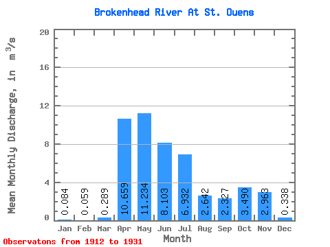
| Statistic | Jan | Feb | Mar | Apr | May | Jun | Jul | Aug | Sep | Oct | Nov | Dec | Annual |
|---|---|---|---|---|---|---|---|---|---|---|---|---|---|
| Mean | 0.08 | 0.06 | 0.29 | 10.66 | 11.23 | 8.10 | 6.93 | 2.64 | 2.33 | 3.49 | 2.96 | 0.34 | 3.21 |
| Standard Deviation | 0.07 | 0.05 | 0.34 | 7.41 | 10.91 | 7.00 | 6.33 | 2.48 | 2.64 | 3.54 | 2.32 | 0.27 | 1.42 |
| Min | 0.00 | 0.00 | 0.09 | 1.42 | 1.33 | 1.07 | 0.60 | 0.06 | 0.11 | 0.17 | 0.15 | 0.07 | 1.36 |
| Max | 0.21 | 0.14 | 1.18 | 28.30 | 47.30 | 25.80 | 22.10 | 8.23 | 11.70 | 13.50 | 8.39 | 0.79 | 5.19 |
| Coefficient of Variation | 0.89 | 0.79 | 1.19 | 0.69 | 0.97 | 0.86 | 0.91 | 0.94 | 1.13 | 1.02 | 0.78 | 0.80 | 0.44 |
 Return to R-Arctic Net Home Page