|
|
|||||||||||||||||
| Point ID: 3086 | Downloads | Plots | Site Data | Code: 05SA001 |
|
|
|||||||||||||||||
| Download | |
|---|---|
| Site Descriptor Information | Site Time Series Data |
| Link to all available data | |
| View: | Time Series | All |
| Units: | m3/s |
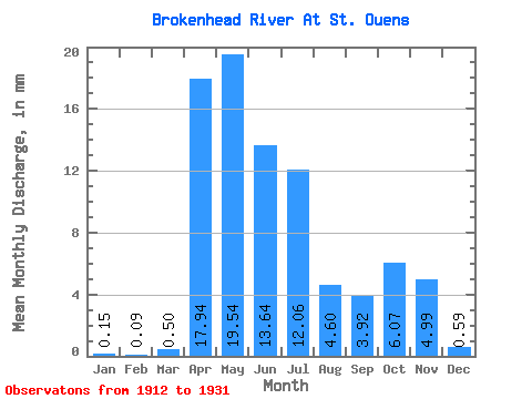
| Statistic | Jan | Feb | Mar | Apr | May | Jun | Jul | Aug | Sep | Oct | Nov | Dec | Annual |
|---|---|---|---|---|---|---|---|---|---|---|---|---|---|
| Mean | 0.15 | 0.09 | 0.50 | 17.94 | 19.54 | 13.64 | 12.05 | 4.59 | 3.92 | 6.07 | 4.99 | 0.59 | 65.80 |
| Standard Deviation | 0.13 | 0.07 | 0.60 | 12.47 | 18.97 | 11.78 | 11.01 | 4.30 | 4.44 | 6.17 | 3.90 | 0.47 | 29.05 |
| Min | 0.00 | 0.00 | 0.15 | 2.39 | 2.31 | 1.80 | 1.05 | 0.11 | 0.19 | 0.29 | 0.25 | 0.12 | 27.97 |
| Max | 0.37 | 0.23 | 2.05 | 47.63 | 82.25 | 43.42 | 38.43 | 14.31 | 19.69 | 23.48 | 14.12 | 1.37 | 106.27 |
| Coefficient of Variation | 0.89 | 0.79 | 1.19 | 0.69 | 0.97 | 0.86 | 0.91 | 0.94 | 1.13 | 1.02 | 0.78 | 0.80 | 0.44 |
 Return to R-Arctic Net Home Page