|
|
|||||||||||||||||
| Point ID: 3080 | Downloads | Plots | Site Data | Code: 05RA002 |
|
|
|||||||||||||||||
| Download | |
|---|---|
| Site Descriptor Information | Site Time Series Data |
| Link to all available data | |
| View: | Time Series | All |
| Units: | mm |
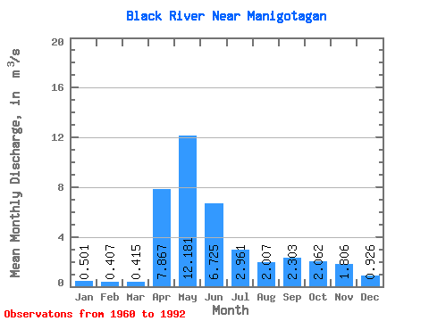
| Statistic | Jan | Feb | Mar | Apr | May | Jun | Jul | Aug | Sep | Oct | Nov | Dec | Annual |
|---|---|---|---|---|---|---|---|---|---|---|---|---|---|
| Mean | 0.50 | 0.41 | 0.41 | 7.87 | 12.18 | 6.72 | 2.96 | 2.01 | 2.30 | 2.06 | 1.81 | 0.93 | 3.34 |
| Standard Deviation | 0.37 | 0.27 | 0.23 | 5.04 | 8.08 | 4.60 | 2.30 | 2.75 | 4.17 | 2.26 | 1.76 | 0.88 | 1.42 |
| Min | 0.02 | 0.02 | 0.03 | 0.58 | 0.57 | 0.56 | 0.14 | 0.03 | 0.02 | 0.01 | 0.02 | 0.02 | 0.86 |
| Max | 1.30 | 1.03 | 0.96 | 18.10 | 31.80 | 16.70 | 8.30 | 12.90 | 17.60 | 9.38 | 6.16 | 3.74 | 6.21 |
| Coefficient of Variation | 0.74 | 0.67 | 0.55 | 0.64 | 0.66 | 0.68 | 0.78 | 1.37 | 1.81 | 1.09 | 0.97 | 0.95 | 0.43 |
 Return to R-Arctic Net Home Page