|
|
|||||||||||||||||
| Point ID: 3080 | Downloads | Plots | Site Data | Code: 05RA002 |
|
|
|||||||||||||||||
| Download | |
|---|---|
| Site Descriptor Information | Site Time Series Data |
| Link to all available data | |
| View: | Time Series | All |
| Units: | m3/s |
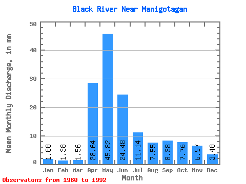
| Statistic | Jan | Feb | Mar | Apr | May | Jun | Jul | Aug | Sep | Oct | Nov | Dec | Annual |
|---|---|---|---|---|---|---|---|---|---|---|---|---|---|
| Mean | 1.88 | 1.40 | 1.56 | 28.64 | 45.82 | 24.48 | 11.14 | 7.55 | 8.38 | 7.76 | 6.57 | 3.48 | 148.20 |
| Standard Deviation | 1.39 | 0.94 | 0.85 | 18.36 | 30.41 | 16.75 | 8.66 | 10.36 | 15.19 | 8.50 | 6.40 | 3.30 | 63.11 |
| Min | 0.06 | 0.07 | 0.12 | 2.12 | 2.14 | 2.02 | 0.53 | 0.10 | 0.09 | 0.04 | 0.06 | 0.09 | 37.96 |
| Max | 4.89 | 3.53 | 3.63 | 65.89 | 119.61 | 60.80 | 31.22 | 48.52 | 64.07 | 35.28 | 22.43 | 14.07 | 275.30 |
| Coefficient of Variation | 0.74 | 0.67 | 0.55 | 0.64 | 0.66 | 0.68 | 0.78 | 1.37 | 1.81 | 1.09 | 0.97 | 0.95 | 0.43 |
 Return to R-Arctic Net Home Page