|
|
|||||||||||||||||
| Point ID: 3072 | Downloads | Plots | Site Data | Code: 05PF069 |
|
|
|||||||||||||||||
| Download | |
|---|---|
| Site Descriptor Information | Site Time Series Data |
| Link to all available data | |
| View: | Time Series | All |
| Units: | mm |
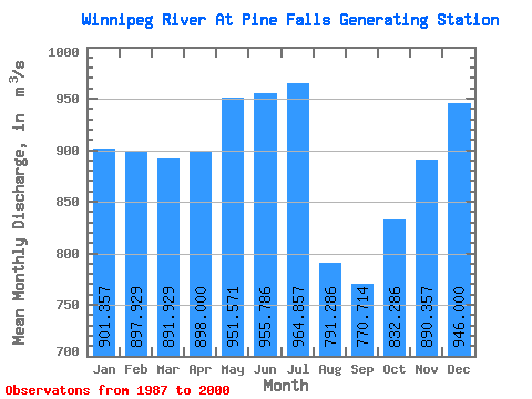
| Statistic | Jan | Feb | Mar | Apr | May | Jun | Jul | Aug | Sep | Oct | Nov | Dec | Annual |
|---|---|---|---|---|---|---|---|---|---|---|---|---|---|
| Mean | 901.36 | 897.93 | 891.93 | 898.00 | 951.57 | 955.79 | 964.86 | 791.29 | 770.71 | 832.29 | 890.36 | 946.00 | 891.01 |
| Standard Deviation | 236.13 | 207.37 | 213.90 | 343.49 | 571.88 | 486.40 | 509.90 | 365.45 | 495.82 | 522.55 | 332.47 | 298.06 | 268.08 |
| Min | 589.00 | 594.00 | 501.00 | 381.00 | 283.00 | 235.00 | 224.00 | 198.00 | 233.00 | 297.00 | 413.00 | 569.00 | 473.92 |
| Max | 1520.00 | 1430.00 | 1360.00 | 1810.00 | 2390.00 | 1850.00 | 1780.00 | 1360.00 | 2070.00 | 2410.00 | 1320.00 | 1580.00 | 1354.50 |
| Coefficient of Variation | 0.26 | 0.23 | 0.24 | 0.38 | 0.60 | 0.51 | 0.53 | 0.46 | 0.64 | 0.63 | 0.37 | 0.32 | 0.30 |
 Return to R-Arctic Net Home Page