|
|
| Point ID: 3072 | Downloads | Plots | Site Data | Code: 05PF069 |
|
| Download | |
|---|---|
| Site Descriptor Information | Site Time Series Data |
| Link to all available data | |
|
|
|
| View: | Statistics | All |
| Units: | mm |
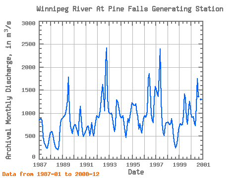
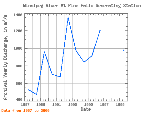
| Year | Jan | Feb | Mar | Apr | May | Jun | Jul | Aug | Sep | Oct | Nov | Dec | Annual | 1987 | 847.00 | 866.00 | 873.00 | 822.00 | 485.00 | 354.00 | 319.00 | 251.00 | 233.00 | 307.00 | 422.00 | 569.00 | 529.00 | 1988 | 589.00 | 594.00 | 501.00 | 381.00 | 283.00 | 235.00 | 224.00 | 198.00 | 298.00 | 668.00 | 840.00 | 876.00 | 473.92 | 1989 | 898.00 | 933.00 | 932.00 | 986.00 | 1090.00 | 1260.00 | 1780.00 | 1070.00 | 720.00 | 630.00 | 550.00 | 687.00 | 961.33 | 1990 | 741.00 | 742.00 | 677.00 | 603.00 | 508.00 | 921.00 | 1140.00 | 854.00 | 621.00 | 492.00 | 537.00 | 581.00 | 701.42 | 1991 | 634.00 | 699.00 | 715.00 | 593.00 | 512.00 | 622.00 | 793.00 | 572.00 | 504.00 | 692.00 | 814.00 | 944.00 | 674.50 | 1992 | 919.00 | 902.00 | 973.00 | 1160.00 | 1430.00 | 1620.00 | 1370.00 | 1050.00 | 2070.00 | 2410.00 | 1320.00 | 1030.00 | 1354.50 | 1993 | 1000.00 | 986.00 | 1000.00 | 871.00 | 708.00 | 600.00 | 760.00 | 1290.00 | 1250.00 | 1210.00 | 1090.00 | 943.00 | 975.67 | 1994 | 898.00 | 900.00 | 937.00 | 773.00 | 598.00 | 472.00 | 658.00 | 876.00 | 787.00 | 922.00 | 1060.00 | 1220.00 | 841.75 | 1995 | 1200.00 | 1170.00 | 1170.00 | 1200.00 | 1010.00 | 916.00 | 652.00 | 769.00 | 643.00 | 560.00 | 780.00 | 905.00 | 914.58 | 1996 | 936.00 | 908.00 | 935.00 | 1040.00 | 1750.00 | 1850.00 | 1490.00 | 987.00 | 829.00 | 787.00 | 1300.00 | 1580.00 | 1199.33 | 1997 | 1520.00 | 1430.00 | 1360.00 | 1810.00 | 2390.00 | 1250.00 | 773.00 | 573.00 | 514.00 | 704.00 | 789.00 | 795.00 | 1159.00 | 1998 | 796.00 | 763.00 | 752.00 | 805.00 | 875.00 | 721.00 | 479.00 | 325.00 | 240.00 | 297.00 | 413.00 | 634.00 | 591.67 | 1999 | 721.00 | 767.00 | 739.00 | 752.00 | 952.00 | 1410.00 | 1320.00 | 903.00 | 761.00 | 1030.00 | 1250.00 | 1120.00 | 977.08 | 2000 | 920.00 | 911.00 | 923.00 | 776.00 | 731.00 | 1150.00 | 1750.00 | 1360.00 | 1320.00 | 943.00 | 1300.00 | 1360.00 | 1120.33 |
|---|
 Return to R-Arctic Net Home Page