|
|
|||||||||||||||||
| Point ID: 3059 | Downloads | Plots | Site Data | Code: 05OJ016 |
|
|
|||||||||||||||||
| Download | |
|---|---|
| Site Descriptor Information | Site Time Series Data |
| Link to all available data | |
| View: | Time Series | All |
| Units: | mm |
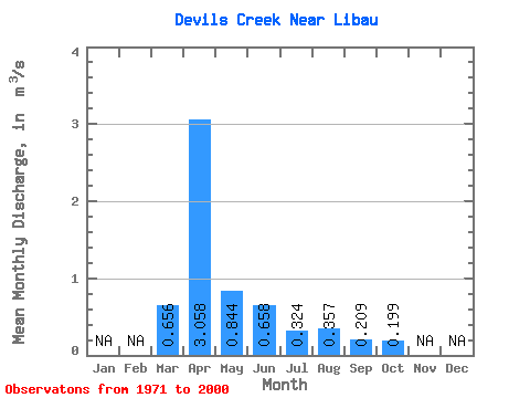
| Statistic | Jan | Feb | Mar | Apr | May | Jun | Jul | Aug | Sep | Oct | Nov | Dec | Annual |
|---|---|---|---|---|---|---|---|---|---|---|---|---|---|
| Mean | 0.66 | 3.06 | 0.84 | 0.66 | 0.32 | 0.36 | 0.21 | 0.20 | |||||
| Standard Deviation | 1.15 | 3.09 | 1.37 | 1.09 | 0.53 | 1.02 | 0.31 | 0.31 | |||||
| Min | 0.00 | 0.08 | 0.05 | 0.04 | 0.03 | 0.02 | 0.02 | 0.02 | |||||
| Max | 4.38 | 11.50 | 5.55 | 4.30 | 2.65 | 4.96 | 1.37 | 1.56 | |||||
| Coefficient of Variation | 1.75 | 1.01 | 1.62 | 1.65 | 1.64 | 2.85 | 1.46 | 1.57 |
 Return to R-Arctic Net Home Page