|
|
|||||||||||||||||
| Point ID: 3059 | Downloads | Plots | Site Data | Code: 05OJ016 |
|
|
|||||||||||||||||
| Download | |
|---|---|
| Site Descriptor Information | Site Time Series Data |
| Link to all available data | |
| View: | Time Series | All |
| Units: | m3/s |
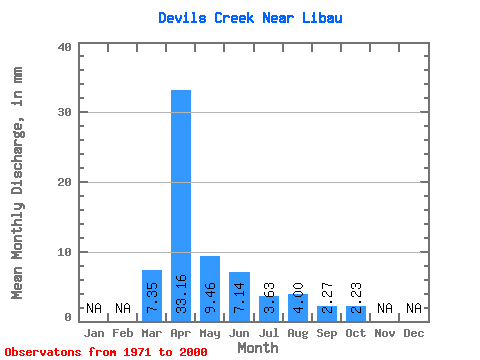
| Statistic | Jan | Feb | Mar | Apr | May | Jun | Jul | Aug | Sep | Oct | Nov | Dec | Annual |
|---|---|---|---|---|---|---|---|---|---|---|---|---|---|
| Mean | 7.35 | 33.17 | 9.45 | 7.14 | 3.63 | 4.00 | 2.27 | 2.23 | |||||
| Standard Deviation | 12.88 | 33.53 | 15.36 | 11.78 | 5.94 | 11.42 | 3.32 | 3.50 | |||||
| Min | 0.00 | 0.86 | 0.59 | 0.39 | 0.28 | 0.20 | 0.18 | 0.22 | |||||
| Max | 49.08 | 124.72 | 62.19 | 46.63 | 29.69 | 55.58 | 14.86 | 17.48 | |||||
| Coefficient of Variation | 1.75 | 1.01 | 1.62 | 1.65 | 1.64 | 2.85 | 1.46 | 1.57 |
 Return to R-Arctic Net Home Page