|
|
|||||||||||||||||
| Point ID: 3053 | Downloads | Plots | Site Data | Code: 05OJ008 |
|
|
|||||||||||||||||
| Download | |
|---|---|
| Site Descriptor Information | Site Time Series Data |
| Link to all available data | |
| View: | Time Series | All |
| Units: | mm |
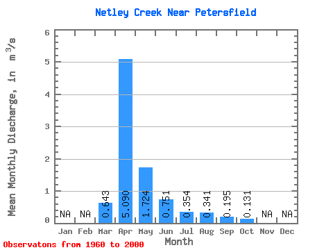
| Statistic | Jan | Feb | Mar | Apr | May | Jun | Jul | Aug | Sep | Oct | Nov | Dec | Annual |
|---|---|---|---|---|---|---|---|---|---|---|---|---|---|
| Mean | 0.64 | 5.09 | 1.72 | 0.75 | 0.35 | 0.34 | 0.20 | 0.13 | |||||
| Standard Deviation | 1.15 | 4.72 | 3.10 | 1.18 | 0.59 | 1.09 | 0.55 | 0.12 | |||||
| Min | 0.00 | 0.08 | 0.02 | 0.01 | 0.00 | 0.00 | 0.00 | 0.00 | |||||
| Max | 4.58 | 22.50 | 13.80 | 5.89 | 3.43 | 6.41 | 3.34 | 0.58 | |||||
| Coefficient of Variation | 1.79 | 0.93 | 1.80 | 1.57 | 1.67 | 3.19 | 2.80 | 0.94 |
 Return to R-Arctic Net Home Page