|
|
|||||||||||||||||
| Point ID: 3053 | Downloads | Plots | Site Data | Code: 05OJ008 |
|
|
|||||||||||||||||
| Download | |
|---|---|
| Site Descriptor Information | Site Time Series Data |
| Link to all available data | |
| View: | Time Series | All |
| Units: | m3/s |
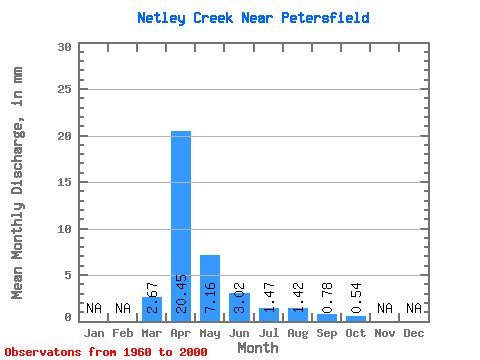
| Statistic | Jan | Feb | Mar | Apr | May | Jun | Jul | Aug | Sep | Oct | Nov | Dec | Annual |
|---|---|---|---|---|---|---|---|---|---|---|---|---|---|
| Mean | 2.67 | 20.45 | 7.16 | 3.02 | 1.47 | 1.42 | 0.78 | 0.54 | |||||
| Standard Deviation | 4.79 | 18.99 | 12.86 | 4.74 | 2.45 | 4.52 | 2.19 | 0.51 | |||||
| Min | 0.00 | 0.31 | 0.10 | 0.05 | 0.00 | 0.00 | 0.00 | 0.01 | |||||
| Max | 19.02 | 90.42 | 57.30 | 23.67 | 14.24 | 26.61 | 13.42 | 2.41 | |||||
| Coefficient of Variation | 1.79 | 0.93 | 1.80 | 1.57 | 1.67 | 3.19 | 2.80 | 0.94 |
 Return to R-Arctic Net Home Page