|
|
|||||||||||||||||
| Point ID: 3052 | Downloads | Plots | Site Data | Code: 05OJ007 |
|
|
|||||||||||||||||
| Download | |
|---|---|
| Site Descriptor Information | Site Time Series Data |
| Link to all available data | |
| View: | Time Series | All |
| Units: | mm |
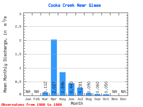
| Statistic | Jan | Feb | Mar | Apr | May | Jun | Jul | Aug | Sep | Oct | Nov | Dec | Annual |
|---|---|---|---|---|---|---|---|---|---|---|---|---|---|
| Mean | 0.11 | 2.03 | 0.85 | 0.44 | 0.28 | 0.09 | 0.06 | 0.05 | |||||
| Standard Deviation | 0.23 | 2.05 | 1.46 | 0.50 | 0.75 | 0.24 | 0.14 | 0.09 | |||||
| Min | 0.00 | 0.02 | 0.01 | 0.00 | 0.00 | 0.00 | 0.00 | 0.00 | |||||
| Max | 0.93 | 6.89 | 7.36 | 1.63 | 4.10 | 1.09 | 0.59 | 0.33 | |||||
| Coefficient of Variation | 2.08 | 1.01 | 1.73 | 1.12 | 2.68 | 2.62 | 2.38 | 1.69 |
 Return to R-Arctic Net Home Page