|
|
|||||||||||||||||
| Point ID: 3052 | Downloads | Plots | Site Data | Code: 05OJ007 |
|
|
|||||||||||||||||
| Download | |
|---|---|
| Site Descriptor Information | Site Time Series Data |
| Link to all available data | |
| View: | Time Series | All |
| Units: | m3/s |
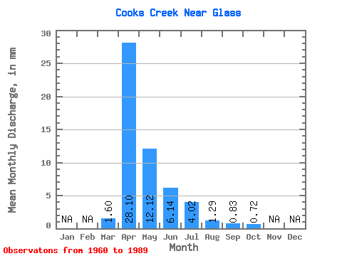
| Statistic | Jan | Feb | Mar | Apr | May | Jun | Jul | Aug | Sep | Oct | Nov | Dec | Annual |
|---|---|---|---|---|---|---|---|---|---|---|---|---|---|
| Mean | 1.60 | 28.09 | 12.12 | 6.14 | 4.03 | 1.29 | 0.84 | 0.72 | |||||
| Standard Deviation | 3.34 | 28.38 | 20.94 | 6.88 | 10.80 | 3.38 | 1.99 | 1.21 | |||||
| Min | 0.00 | 0.24 | 0.14 | 0.01 | 0.00 | 0.00 | 0.00 | 0.00 | |||||
| Max | 13.33 | 95.50 | 105.40 | 22.59 | 58.72 | 15.61 | 8.12 | 4.78 | |||||
| Coefficient of Variation | 2.08 | 1.01 | 1.73 | 1.12 | 2.68 | 2.62 | 2.38 | 1.69 |
 Return to R-Arctic Net Home Page