|
|
|||||||||||||||||
| Point ID: 305 | Downloads | Plots | Site Data | Code: 05BL006 |
|
|
|||||||||||||||||
| Download | |
|---|---|
| Site Descriptor Information | Site Time Series Data |
| Link to all available data | |
| View: | Time Series | All |
| Units: | mm |
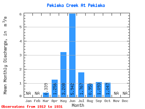
| Statistic | Jan | Feb | Mar | Apr | May | Jun | Jul | Aug | Sep | Oct | Nov | Dec | Annual |
|---|---|---|---|---|---|---|---|---|---|---|---|---|---|
| Mean | 0.34 | 1.26 | 3.21 | 5.94 | 1.77 | 0.95 | 1.09 | 1.05 | |||||
| Standard Deviation | 0.32 | 0.56 | 1.95 | 4.56 | 1.44 | 0.78 | 1.42 | 1.12 | |||||
| Min | 0.10 | 0.67 | 0.96 | 0.26 | 0.09 | 0.13 | 0.15 | 0.19 | |||||
| Max | 1.19 | 2.58 | 7.85 | 15.00 | 4.41 | 2.45 | 4.64 | 4.51 | |||||
| Coefficient of Variation | 0.94 | 0.44 | 0.61 | 0.77 | 0.81 | 0.82 | 1.30 | 1.07 |
 Return to R-Arctic Net Home Page