|
|
|||||||||||||||||
| Point ID: 305 | Downloads | Plots | Site Data | Code: 05BL006 |
|
|
|||||||||||||||||
| Download | |
|---|---|
| Site Descriptor Information | Site Time Series Data |
| Link to all available data | |
| View: | Time Series | All |
| Units: | m3/s |
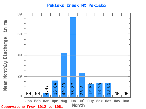
| Statistic | Jan | Feb | Mar | Apr | May | Jun | Jul | Aug | Sep | Oct | Nov | Dec | Annual |
|---|---|---|---|---|---|---|---|---|---|---|---|---|---|
| Mean | 4.47 | 16.04 | 42.32 | 75.86 | 23.31 | 12.53 | 13.96 | 13.81 | |||||
| Standard Deviation | 4.21 | 7.10 | 25.69 | 58.28 | 18.99 | 10.30 | 18.18 | 14.84 | |||||
| Min | 1.36 | 8.57 | 12.70 | 3.26 | 1.20 | 1.77 | 1.93 | 2.49 | |||||
| Max | 15.70 | 32.94 | 103.56 | 191.53 | 58.18 | 32.32 | 59.25 | 59.50 | |||||
| Coefficient of Variation | 0.94 | 0.44 | 0.61 | 0.77 | 0.81 | 0.82 | 1.30 | 1.07 |
 Return to R-Arctic Net Home Page