|
|
|||||||||||||||||
| Point ID: 3048 | Downloads | Plots | Site Data | Code: 05OH008 |
|
|
|||||||||||||||||
| Download | |
|---|---|
| Site Descriptor Information | Site Time Series Data |
| Link to all available data | |
| View: | Time Series | All |
| Units: | mm |
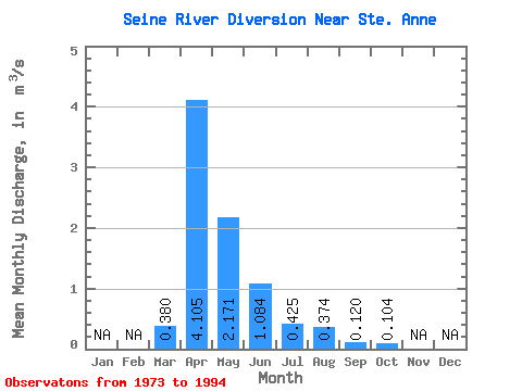
| Statistic | Jan | Feb | Mar | Apr | May | Jun | Jul | Aug | Sep | Oct | Nov | Dec | Annual |
|---|---|---|---|---|---|---|---|---|---|---|---|---|---|
| Mean | 0.38 | 4.11 | 2.17 | 1.08 | 0.42 | 0.37 | 0.12 | 0.10 | |||||
| Standard Deviation | 0.55 | 5.29 | 4.09 | 1.75 | 0.74 | 1.65 | 0.50 | 0.26 | |||||
| Min | 0.00 | 0.00 | 0.00 | 0.00 | 0.00 | 0.00 | 0.00 | 0.00 | |||||
| Max | 1.70 | 20.60 | 16.40 | 5.81 | 2.23 | 7.57 | 2.30 | 1.15 | |||||
| Coefficient of Variation | 1.46 | 1.29 | 1.88 | 1.62 | 1.73 | 4.41 | 4.18 | 2.49 |
 Return to R-Arctic Net Home Page