|
|
|||||||||||||||||
| Point ID: 3048 | Downloads | Plots | Site Data | Code: 05OH008 |
|
|
|||||||||||||||||
| Download | |
|---|---|
| Site Descriptor Information | Site Time Series Data |
| Link to all available data | |
| View: | Time Series | All |
| Units: | m3/s |
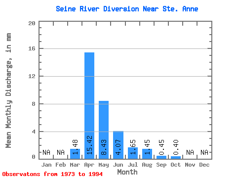
| Statistic | Jan | Feb | Mar | Apr | May | Jun | Jul | Aug | Sep | Oct | Nov | Dec | Annual |
|---|---|---|---|---|---|---|---|---|---|---|---|---|---|
| Mean | 1.48 | 15.42 | 8.43 | 4.07 | 1.65 | 1.45 | 0.45 | 0.40 | |||||
| Standard Deviation | 2.15 | 19.88 | 15.88 | 6.59 | 2.86 | 6.40 | 1.89 | 1.00 | |||||
| Min | 0.00 | 0.00 | 0.00 | 0.00 | 0.00 | 0.00 | 0.00 | 0.00 | |||||
| Max | 6.60 | 77.38 | 63.65 | 21.82 | 8.65 | 29.38 | 8.64 | 4.46 | |||||
| Coefficient of Variation | 1.46 | 1.29 | 1.88 | 1.62 | 1.73 | 4.41 | 4.18 | 2.49 |
 Return to R-Arctic Net Home Page