|
|
|||||||||||||||||
| Point ID: 3044 | Downloads | Plots | Site Data | Code: 05OH001 |
|
|
|||||||||||||||||
| Download | |
|---|---|
| Site Descriptor Information | Site Time Series Data |
| Link to all available data | |
| View: | Time Series | All |
| Units: | mm |
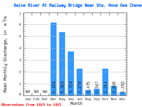
| Statistic | Jan | Feb | Mar | Apr | May | Jun | Jul | Aug | Sep | Oct | Nov | Dec | Annual |
|---|---|---|---|---|---|---|---|---|---|---|---|---|---|
| Mean | 6.16 | 5.37 | 3.72 | 2.28 | 0.47 | 0.57 | 2.26 | 0.81 | 0.28 | ||||
| Standard Deviation | 4.41 | 5.08 | 4.95 | 3.45 | 0.39 | 0.71 | 2.20 | 0.46 | |||||
| Min | 1.05 | 0.73 | 0.41 | 0.12 | 0.00 | 0.04 | 0.14 | 0.48 | 0.28 | ||||
| Max | 14.80 | 20.70 | 19.20 | 12.30 | 1.17 | 2.31 | 5.41 | 1.13 | 0.28 | ||||
| Coefficient of Variation | 0.72 | 0.95 | 1.33 | 1.52 | 0.82 | 1.25 | 0.97 | 0.56 |
 Return to R-Arctic Net Home Page