|
|
|||||||||||||||||
| Point ID: 3044 | Downloads | Plots | Site Data | Code: 05OH001 |
|
|
|||||||||||||||||
| Download | |
|---|---|
| Site Descriptor Information | Site Time Series Data |
| Link to all available data | |
| View: | Time Series | All |
| Units: | m3/s |
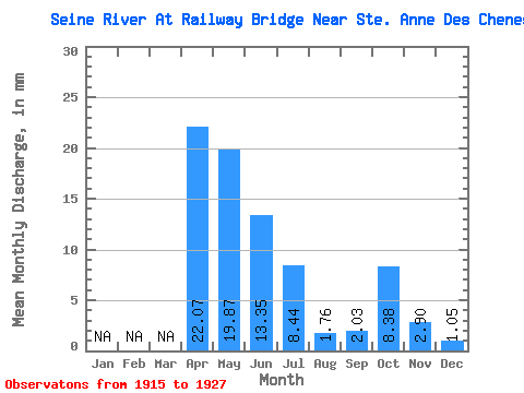
| Statistic | Jan | Feb | Mar | Apr | May | Jun | Jul | Aug | Sep | Oct | Nov | Dec | Annual |
|---|---|---|---|---|---|---|---|---|---|---|---|---|---|
| Mean | 22.07 | 19.87 | 13.35 | 8.44 | 1.76 | 2.03 | 8.38 | 2.90 | 1.05 | ||||
| Standard Deviation | 15.82 | 18.82 | 17.74 | 12.78 | 1.45 | 2.55 | 8.15 | 1.64 | |||||
| Min | 3.76 | 2.70 | 1.48 | 0.45 | 0.00 | 0.15 | 0.53 | 1.74 | 1.05 | ||||
| Max | 53.06 | 76.67 | 68.83 | 45.56 | 4.33 | 8.28 | 20.04 | 4.05 | 1.05 | ||||
| Coefficient of Variation | 0.72 | 0.95 | 1.33 | 1.52 | 0.82 | 1.25 | 0.97 | 0.56 |
 Return to R-Arctic Net Home Page