|
|
|||||||||||||||||
| Point ID: 3035 | Downloads | Plots | Site Data | Code: 05OG001 |
|
|
|||||||||||||||||
| Download | |
|---|---|
| Site Descriptor Information | Site Time Series Data |
| Link to all available data | |
| View: | Time Series | All |
| Units: | mm |
| Statistic | Jan | Feb | Mar | Apr | May | Jun | Jul | Aug | Sep | Oct | Nov | Dec | Annual |
|---|---|---|---|---|---|---|---|---|---|---|---|---|---|
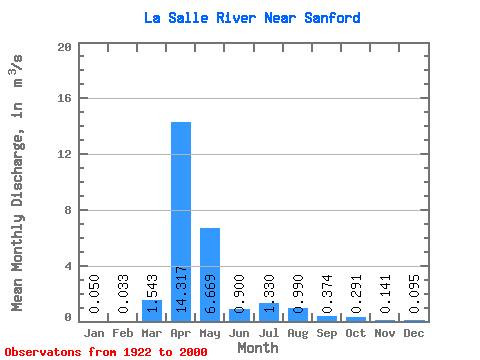
| Mean | 0.05 | 0.03 | 1.54 | 14.32 | 6.67 | 0.90 | 1.33 | 0.99 | 0.37 | 0.29 | 0.14 | 0.10 | 2.23 |
| Standard Deviation | 0.07 | 0.05 | 3.13 | 12.93 | 12.34 | 1.34 | 2.91 | 2.99 | 0.70 | 0.67 | 0.22 | 0.16 | 2.04 |
| Min | 0.00 | 0.00 | 0.00 | 0.34 | 0.00 | 0.00 | 0.00 | 0.00 | 0.00 | 0.00 | 0.00 | 0.00 | 0.16 |
| Max | 0.20 | 0.24 | 14.30 | 49.00 | 48.60 | 7.05 | 14.70 | 15.20 | 3.33 | 4.02 | 0.97 | 0.74 | 7.65 |
| Coefficient of Variation | 1.41 | 1.62 | 2.03 | 0.90 | 1.85 | 1.49 | 2.19 | 3.02 | 1.88 | 2.29 | 1.53 | 1.69 | 0.92 |
 Return to R-Arctic Net Home Page