|
|
|||||||||||||||||
| Point ID: 3035 | Downloads | Plots | Site Data | Code: 05OG001 |
|
|
|||||||||||||||||
| Download | |
|---|---|
| Site Descriptor Information | Site Time Series Data |
| Link to all available data | |
| View: | Time Series | All |
| Units: | m3/s |
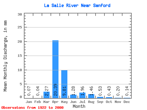
| Statistic | Jan | Feb | Mar | Apr | May | Jun | Jul | Aug | Sep | Oct | Nov | Dec | Annual |
|---|---|---|---|---|---|---|---|---|---|---|---|---|---|
| Mean | 0.07 | 0.04 | 2.27 | 20.39 | 9.81 | 1.28 | 1.96 | 1.46 | 0.53 | 0.43 | 0.20 | 0.14 | 38.57 |
| Standard Deviation | 0.10 | 0.07 | 4.61 | 18.42 | 18.16 | 1.91 | 4.28 | 4.41 | 1.00 | 0.98 | 0.31 | 0.23 | 35.44 |
| Min | 0.00 | 0.00 | 0.00 | 0.49 | 0.00 | 0.00 | 0.00 | 0.00 | 0.00 | 0.00 | 0.00 | 0.00 | 2.71 |
| Max | 0.30 | 0.32 | 21.04 | 69.78 | 71.51 | 10.04 | 21.63 | 22.37 | 4.74 | 5.92 | 1.38 | 1.08 | 132.67 |
| Coefficient of Variation | 1.41 | 1.62 | 2.03 | 0.90 | 1.85 | 1.49 | 2.19 | 3.02 | 1.88 | 2.29 | 1.53 | 1.69 | 0.92 |
 Return to R-Arctic Net Home Page