|
|
|||||||||||||||||
| Point ID: 3031 | Downloads | Plots | Site Data | Code: 05OF019 |
|
|
|||||||||||||||||
| Download | |
|---|---|
| Site Descriptor Information | Site Time Series Data |
| Link to all available data | |
| View: | Time Series | All |
| Units: | mm |
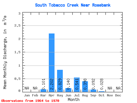
| Statistic | Jan | Feb | Mar | Apr | May | Jun | Jul | Aug | Sep | Oct | Nov | Dec | Annual |
|---|---|---|---|---|---|---|---|---|---|---|---|---|---|
| Mean | 0.10 | 2.20 | 0.83 | 0.14 | 0.54 | 0.40 | 0.09 | 0.03 | |||||
| Standard Deviation | 0.15 | 2.02 | 0.81 | 0.18 | 0.43 | 0.90 | 0.20 | 0.06 | |||||
| Min | 0.00 | 0.15 | 0.04 | 0.02 | 0.03 | 0.00 | 0.00 | 0.00 | |||||
| Max | 0.40 | 5.63 | 2.46 | 0.53 | 1.12 | 2.24 | 0.51 | 0.16 | |||||
| Coefficient of Variation | 1.51 | 0.92 | 0.97 | 1.28 | 0.79 | 2.27 | 2.22 | 2.28 |
 Return to R-Arctic Net Home Page