|
|
|||||||||||||||||
| Point ID: 3031 | Downloads | Plots | Site Data | Code: 05OF019 |
|
|
|||||||||||||||||
| Download | |
|---|---|
| Site Descriptor Information | Site Time Series Data |
| Link to all available data | |
| View: | Time Series | All |
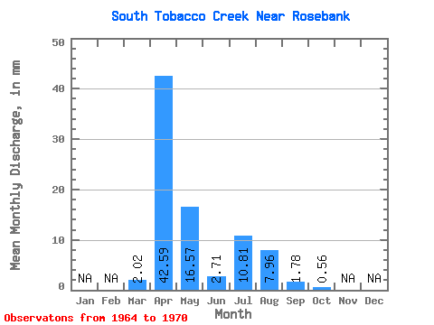
| Units: | m3/s |
| Statistic | Jan | Feb | Mar | Apr | May | Jun | Jul | Aug | Sep | Oct | Nov | Dec | Annual |
|---|---|---|---|---|---|---|---|---|---|---|---|---|---|
| Mean | 2.02 | 42.59 | 16.57 | 2.71 | 10.82 | 7.95 | 1.79 | 0.56 | |||||
| Standard Deviation | 3.04 | 39.17 | 16.16 | 3.48 | 8.56 | 18.06 | 3.96 | 1.27 | |||||
| Min | 0.00 | 2.88 | 0.76 | 0.39 | 0.68 | 0.00 | 0.00 | 0.00 | |||||
| Max | 8.01 | 108.90 | 49.16 | 10.23 | 22.38 | 44.77 | 9.87 | 3.14 | |||||
| Coefficient of Variation | 1.51 | 0.92 | 0.97 | 1.28 | 0.79 | 2.27 | 2.22 | 2.28 |
 Return to R-Arctic Net Home Page