|
|
|||||||||||||||||
| Point ID: 3017 | Downloads | Plots | Site Data | Code: 05OF002 |
|
|
|||||||||||||||||
| Download | |
|---|---|
| Site Descriptor Information | Site Time Series Data |
| Link to all available data | |
| View: | Time Series | All |
| Units: | mm |
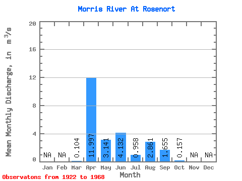
| Statistic | Jan | Feb | Mar | Apr | May | Jun | Jul | Aug | Sep | Oct | Nov | Dec | Annual |
|---|---|---|---|---|---|---|---|---|---|---|---|---|---|
| Mean | 0.10 | 12.00 | 3.14 | 4.13 | 0.96 | 2.86 | 1.66 | 0.16 | |||||
| Standard Deviation | 0.20 | 14.41 | 2.47 | 6.00 | 1.00 | 5.23 | 2.15 | 0.31 | |||||
| Min | 0.00 | 3.09 | 1.05 | 0.52 | 0.00 | 0.00 | 0.00 | 0.00 | |||||
| Max | 0.41 | 33.30 | 8.15 | 13.10 | 2.01 | 10.70 | 4.53 | 0.63 | |||||
| Coefficient of Variation | 1.97 | 1.20 | 0.79 | 1.45 | 1.04 | 1.83 | 1.30 | 2.00 |
 Return to R-Arctic Net Home Page