|
|
|||||||||||||||||
| Point ID: 3017 | Downloads | Plots | Site Data | Code: 05OF002 |
|
|
|||||||||||||||||
| Download | |
|---|---|
| Site Descriptor Information | Site Time Series Data |
| Link to all available data | |
| View: | Time Series | All |
| Units: | m3/s |
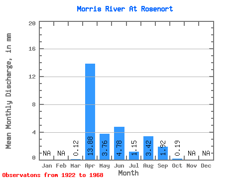
| Statistic | Jan | Feb | Mar | Apr | May | Jun | Jul | Aug | Sep | Oct | Nov | Dec | Annual |
|---|---|---|---|---|---|---|---|---|---|---|---|---|---|
| Mean | 0.12 | 13.88 | 3.76 | 4.78 | 1.15 | 3.42 | 1.92 | 0.19 | |||||
| Standard Deviation | 0.24 | 16.68 | 2.96 | 6.94 | 1.20 | 6.25 | 2.49 | 0.38 | |||||
| Min | 0.00 | 3.58 | 1.25 | 0.60 | 0.00 | 0.00 | 0.00 | 0.00 | |||||
| Max | 0.49 | 38.53 | 9.74 | 15.16 | 2.40 | 12.79 | 5.24 | 0.75 | |||||
| Coefficient of Variation | 1.97 | 1.20 | 0.79 | 1.45 | 1.04 | 1.83 | 1.30 | 2.00 |
 Return to R-Arctic Net Home Page