|
|
|||||||||||||||||
| Point ID: 3014 | Downloads | Plots | Site Data | Code: 05OE011 |
|
|
|||||||||||||||||
| Download | |
|---|---|
| Site Descriptor Information | Site Time Series Data |
| Link to all available data | |
| View: | Time Series | All |
| Units: | mm |
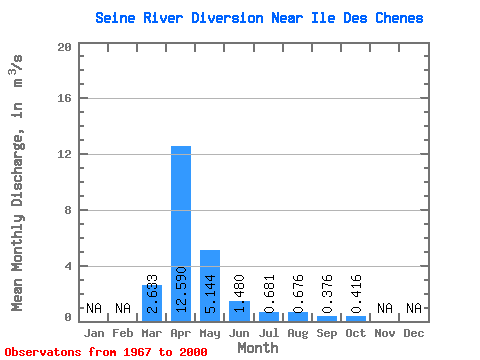
| Statistic | Jan | Feb | Mar | Apr | May | Jun | Jul | Aug | Sep | Oct | Nov | Dec | Annual |
|---|---|---|---|---|---|---|---|---|---|---|---|---|---|
| Mean | 2.63 | 12.59 | 5.14 | 1.48 | 0.68 | 0.68 | 0.38 | 0.42 | |||||
| Standard Deviation | 4.30 | 15.29 | 7.36 | 2.41 | 0.90 | 2.01 | 0.72 | 0.72 | |||||
| Min | 0.00 | 0.32 | 0.04 | 0.01 | 0.03 | 0.00 | 0.01 | 0.04 | |||||
| Max | 17.10 | 62.10 | 24.10 | 8.30 | 3.11 | 9.56 | 2.69 | 3.59 | |||||
| Coefficient of Variation | 1.63 | 1.21 | 1.43 | 1.63 | 1.31 | 2.97 | 1.93 | 1.74 |
 Return to R-Arctic Net Home Page