|
|
|||||||||||||||||
| Point ID: 3014 | Downloads | Plots | Site Data | Code: 05OE011 |
|
|
|||||||||||||||||
| Download | |
|---|---|
| Site Descriptor Information | Site Time Series Data |
| Link to all available data | |
| View: | Time Series | All |
| Units: | m3/s |
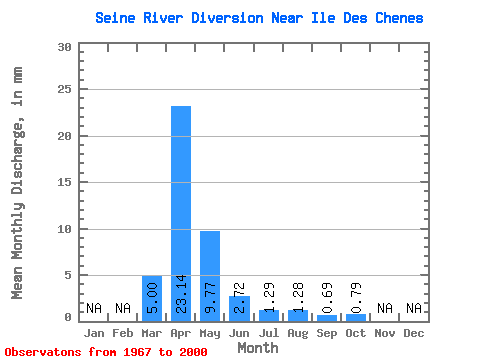
| Statistic | Jan | Feb | Mar | Apr | May | Jun | Jul | Aug | Sep | Oct | Nov | Dec | Annual |
|---|---|---|---|---|---|---|---|---|---|---|---|---|---|
| Mean | 5.00 | 23.14 | 9.77 | 2.72 | 1.29 | 1.28 | 0.69 | 0.79 | |||||
| Standard Deviation | 8.16 | 28.10 | 13.98 | 4.43 | 1.70 | 3.81 | 1.33 | 1.37 | |||||
| Min | 0.00 | 0.59 | 0.07 | 0.03 | 0.05 | 0.01 | 0.02 | 0.08 | |||||
| Max | 32.48 | 114.16 | 45.77 | 15.26 | 5.91 | 18.16 | 4.95 | 6.82 | |||||
| Coefficient of Variation | 1.63 | 1.21 | 1.43 | 1.63 | 1.31 | 2.97 | 1.93 | 1.74 |
 Return to R-Arctic Net Home Page