|
|
|||||||||||||||||
| Point ID: 3010 | Downloads | Plots | Site Data | Code: 05OE007 |
|
|
|||||||||||||||||
| Download | |
|---|---|
| Site Descriptor Information | Site Time Series Data |
| Link to all available data | |
| View: | Time Series | All |
| Units: | mm |
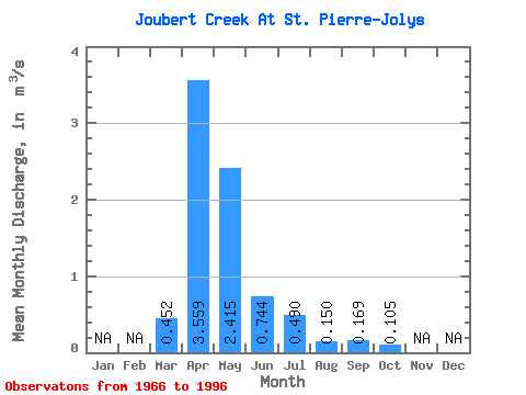
| Statistic | Jan | Feb | Mar | Apr | May | Jun | Jul | Aug | Sep | Oct | Nov | Dec | Annual |
|---|---|---|---|---|---|---|---|---|---|---|---|---|---|
| Mean | 0.45 | 3.56 | 2.42 | 0.74 | 0.49 | 0.15 | 0.17 | 0.10 | |||||
| Standard Deviation | 0.96 | 4.36 | 3.98 | 1.27 | 0.92 | 0.36 | 0.59 | 0.15 | |||||
| Min | 0.00 | 0.12 | 0.03 | 0.00 | 0.00 | 0.00 | 0.00 | 0.00 | |||||
| Max | 5.20 | 16.20 | 13.10 | 5.25 | 3.85 | 1.80 | 3.02 | 0.74 | |||||
| Coefficient of Variation | 2.12 | 1.22 | 1.65 | 1.71 | 1.88 | 2.41 | 3.52 | 1.42 |
 Return to R-Arctic Net Home Page