|
|
|||||||||||||||||
| Point ID: 3010 | Downloads | Plots | Site Data | Code: 05OE007 |
|
|
|||||||||||||||||
| Download | |
|---|---|
| Site Descriptor Information | Site Time Series Data |
| Link to all available data | |
| View: | Time Series | All |
| Units: | m3/s |
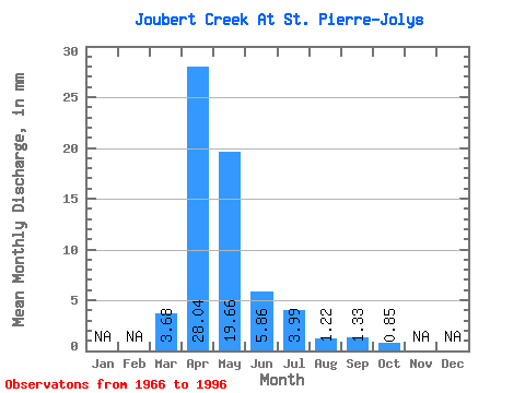
| Statistic | Jan | Feb | Mar | Apr | May | Jun | Jul | Aug | Sep | Oct | Nov | Dec | Annual |
|---|---|---|---|---|---|---|---|---|---|---|---|---|---|
| Mean | 3.68 | 28.04 | 19.66 | 5.87 | 3.99 | 1.23 | 1.33 | 0.85 | |||||
| Standard Deviation | 7.81 | 34.33 | 32.36 | 10.00 | 7.48 | 2.96 | 4.68 | 1.21 | |||||
| Min | 0.00 | 0.98 | 0.27 | 0.02 | 0.00 | 0.00 | 0.00 | 0.00 | |||||
| Max | 42.33 | 127.63 | 106.63 | 41.36 | 31.34 | 14.65 | 23.79 | 6.03 | |||||
| Coefficient of Variation | 2.12 | 1.22 | 1.65 | 1.71 | 1.88 | 2.41 | 3.52 | 1.42 |
 Return to R-Arctic Net Home Page