|
|
|||||||||||||||||
| Point ID: 3001 | Downloads | Plots | Site Data | Code: 05OD030 |
|
|
|||||||||||||||||
| Download | |
|---|---|
| Site Descriptor Information | Site Time Series Data |
| Link to all available data | |
| View: | Time Series | All |
| Units: | mm |
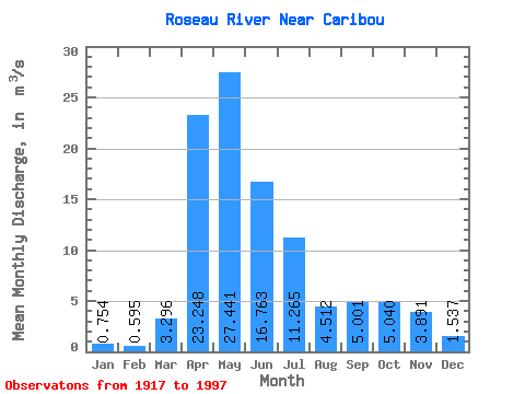
| Statistic | Jan | Feb | Mar | Apr | May | Jun | Jul | Aug | Sep | Oct | Nov | Dec | Annual |
|---|---|---|---|---|---|---|---|---|---|---|---|---|---|
| Mean | 0.75 | 0.59 | 3.30 | 23.25 | 27.44 | 16.76 | 11.27 | 4.51 | 5.00 | 5.04 | 3.89 | 1.54 | 8.94 |
| Standard Deviation | 0.71 | 0.50 | 4.36 | 14.18 | 24.48 | 16.60 | 12.69 | 8.43 | 8.65 | 7.06 | 4.06 | 1.64 | 5.03 |
| Min | 0.00 | 0.00 | 0.04 | 1.08 | 0.76 | 0.19 | 0.02 | 0.06 | 0.01 | 0.00 | 0.01 | 0.01 | 1.24 |
| Max | 3.79 | 2.14 | 22.40 | 61.40 | 85.80 | 73.30 | 46.80 | 44.80 | 41.10 | 36.90 | 20.20 | 8.58 | 18.55 |
| Coefficient of Variation | 0.95 | 0.84 | 1.32 | 0.61 | 0.89 | 0.99 | 1.13 | 1.87 | 1.73 | 1.40 | 1.04 | 1.06 | 0.56 |
 Return to R-Arctic Net Home Page