|
|
|||||||||||||||||
| Point ID: 3001 | Downloads | Plots | Site Data | Code: 05OD030 |
|
|
|||||||||||||||||
| Download | |
|---|---|
| Site Descriptor Information | Site Time Series Data |
| Link to all available data | |
| View: | Time Series | All |
| Units: | m3/s |
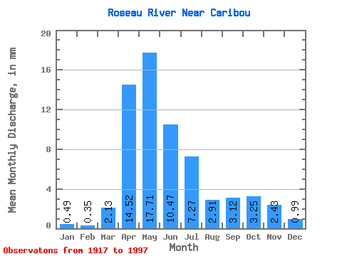
| Statistic | Jan | Feb | Mar | Apr | May | Jun | Jul | Aug | Sep | Oct | Nov | Dec | Annual |
|---|---|---|---|---|---|---|---|---|---|---|---|---|---|
| Mean | 0.49 | 0.35 | 2.13 | 14.52 | 17.71 | 10.47 | 7.27 | 2.91 | 3.12 | 3.25 | 2.43 | 0.99 | 67.96 |
| Standard Deviation | 0.46 | 0.29 | 2.81 | 8.86 | 15.79 | 10.37 | 8.19 | 5.44 | 5.40 | 4.56 | 2.54 | 1.06 | 38.26 |
| Min | 0.00 | 0.00 | 0.03 | 0.68 | 0.49 | 0.12 | 0.01 | 0.04 | 0.01 | 0.00 | 0.00 | 0.01 | 9.43 |
| Max | 2.45 | 1.26 | 14.46 | 38.35 | 55.37 | 45.78 | 30.20 | 28.91 | 25.67 | 23.81 | 12.62 | 5.54 | 141.09 |
| Coefficient of Variation | 0.95 | 0.84 | 1.32 | 0.61 | 0.89 | 0.99 | 1.13 | 1.87 | 1.73 | 1.40 | 1.04 | 1.06 | 0.56 |
 Return to R-Arctic Net Home Page