|
|
|||||||||||||||||
| Point ID: 2990 | Downloads | Plots | Site Data | Code: 05OC023 |
|
|
|||||||||||||||||
| Download | |
|---|---|
| Site Descriptor Information | Site Time Series Data |
| Link to all available data | |
| View: | Time Series | All |
| Units: | mm |
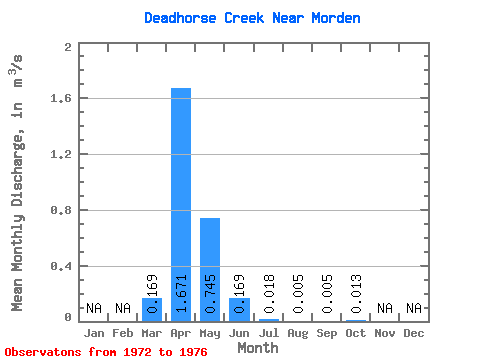
| Statistic | Jan | Feb | Mar | Apr | May | Jun | Jul | Aug | Sep | Oct | Nov | Dec | Annual |
|---|---|---|---|---|---|---|---|---|---|---|---|---|---|
| Mean | 0.17 | 1.67 | 0.74 | 0.17 | 0.02 | 0.01 | 0.01 | 0.01 | |||||
| Standard Deviation | 0.37 | 1.89 | 1.35 | 0.25 | 0.03 | 0.01 | 0.01 | 0.03 | |||||
| Min | 0.00 | 0.01 | 0.01 | 0.00 | 0.00 | 0.00 | 0.00 | 0.00 | |||||
| Max | 0.83 | 4.77 | 3.14 | 0.58 | 0.07 | 0.02 | 0.02 | 0.07 | |||||
| Coefficient of Variation | 2.17 | 1.13 | 1.81 | 1.48 | 1.59 | 2.12 | 2.24 | 2.15 |
 Return to R-Arctic Net Home Page