|
|
| Point ID: 2990 | Downloads | Plots | Site Data | Code: 05OC023 |
|
| Download | |
|---|---|
| Site Descriptor Information | Site Time Series Data |
| Link to all available data | |
|
|
|
| View: | Statistics | All |
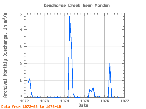
| Units: | mm |
| Year | Jan | Feb | Mar | Apr | May | Jun | Jul | Aug | Sep | Oct | Nov | Dec | Annual | 1972 | 0.83 | 1.10 | 0.20 | 0.01 | 0.02 | 0.00 | 0.00 | 0.00 | 1973 | 0.01 | 0.01 | 0.01 | 0.00 | 0.00 | 0.00 | 0.00 | 0.00 | 1974 | 0.00 | 4.77 | 3.14 | 0.24 | 0.00 | 0.00 | 0.00 | 0.00 | 1975 | 0.00 | 0.46 | 0.34 | 0.58 | 0.07 | 0.02 | 0.02 | 0.07 | 1976 | 0.01 | 2.02 | 0.03 | 0.02 | 0.00 | 0.00 | 0.00 | 0.00 |
|---|
 Return to R-Arctic Net Home Page