|
|
|||||||||||||||||
| Point ID: 2988 | Downloads | Plots | Site Data | Code: 05OC019 |
|
|
|||||||||||||||||
| Download | |
|---|---|
| Site Descriptor Information | Site Time Series Data |
| Link to all available data | |
| View: | Time Series | All |
| Units: | mm |
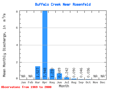
| Statistic | Jan | Feb | Mar | Apr | May | Jun | Jul | Aug | Sep | Oct | Nov | Dec | Annual |
|---|---|---|---|---|---|---|---|---|---|---|---|---|---|
| Mean | 1.53 | 7.95 | 1.23 | 0.69 | 0.24 | 0.09 | 0.05 | 0.04 | |||||
| Standard Deviation | 2.83 | 11.03 | 2.50 | 2.06 | 0.82 | 0.38 | 0.12 | 0.07 | |||||
| Min | 0.00 | 0.00 | 0.00 | 0.00 | 0.00 | 0.00 | 0.00 | 0.00 | |||||
| Max | 11.50 | 43.40 | 11.10 | 10.40 | 4.07 | 1.83 | 0.57 | 0.34 | |||||
| Coefficient of Variation | 1.85 | 1.39 | 2.03 | 2.99 | 3.40 | 4.15 | 2.69 | 2.03 |
 Return to R-Arctic Net Home Page