|
|
|||||||||||||||||
| Point ID: 2988 | Downloads | Plots | Site Data | Code: 05OC019 |
|
|
|||||||||||||||||
| Download | |
|---|---|
| Site Descriptor Information | Site Time Series Data |
| Link to all available data | |
| View: | Time Series | All |
| Units: | m3/s |
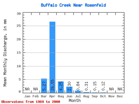
| Statistic | Jan | Feb | Mar | Apr | May | Jun | Jul | Aug | Sep | Oct | Nov | Dec | Annual |
|---|---|---|---|---|---|---|---|---|---|---|---|---|---|
| Mean | 5.27 | 26.55 | 4.24 | 2.30 | 0.84 | 0.31 | 0.15 | 0.12 | |||||
| Standard Deviation | 9.75 | 36.85 | 8.62 | 6.88 | 2.84 | 1.29 | 0.41 | 0.25 | |||||
| Min | 0.00 | 0.00 | 0.00 | 0.00 | 0.00 | 0.00 | 0.00 | 0.00 | |||||
| Max | 39.69 | 144.97 | 38.31 | 34.74 | 14.05 | 6.32 | 1.90 | 1.17 | |||||
| Coefficient of Variation | 1.85 | 1.39 | 2.03 | 2.99 | 3.40 | 4.15 | 2.69 | 2.03 |
 Return to R-Arctic Net Home Page