|
|
|||||||||||||||||
| Point ID: 298 | Downloads | Plots | Site Data | Code: 05BJ010 |
|
|
|||||||||||||||||
| Download | |
|---|---|
| Site Descriptor Information | Site Time Series Data |
| Link to all available data | |
| View: | Time Series | All |
| Units: | mm |
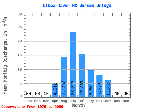
| Statistic | Jan | Feb | Mar | Apr | May | Jun | Jul | Aug | Sep | Oct | Nov | Dec | Annual |
|---|---|---|---|---|---|---|---|---|---|---|---|---|---|
| Mean | 4.81 | 14.30 | 23.33 | 15.39 | 9.66 | 7.88 | 6.34 | ||||||
| Standard Deviation | 1.26 | 8.63 | 11.63 | 8.30 | 4.22 | 3.48 | 1.92 | ||||||
| Min | 2.76 | 4.99 | 8.00 | 5.90 | 3.02 | 4.31 | 3.85 | ||||||
| Max | 6.62 | 35.00 | 51.10 | 35.10 | 23.60 | 17.30 | 11.60 | ||||||
| Coefficient of Variation | 0.26 | 0.60 | 0.50 | 0.54 | 0.44 | 0.44 | 0.30 |
 Return to R-Arctic Net Home Page