|
|
|||||||||||||||||
| Point ID: 298 | Downloads | Plots | Site Data | Code: 05BJ010 |
|
|
|||||||||||||||||
| Download | |
|---|---|
| Site Descriptor Information | Site Time Series Data |
| Link to all available data | |
| View: | Time Series | All |
| Units: | m3/s |
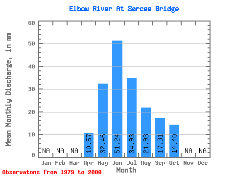
| Statistic | Jan | Feb | Mar | Apr | May | Jun | Jul | Aug | Sep | Oct | Nov | Dec | Annual |
|---|---|---|---|---|---|---|---|---|---|---|---|---|---|
| Mean | 10.57 | 32.46 | 51.24 | 34.92 | 21.93 | 17.31 | 14.39 | ||||||
| Standard Deviation | 2.77 | 19.58 | 25.54 | 18.84 | 9.57 | 7.63 | 4.35 | ||||||
| Min | 6.06 | 11.32 | 17.57 | 13.39 | 6.85 | 9.47 | 8.74 | ||||||
| Max | 14.54 | 79.43 | 112.25 | 79.66 | 53.56 | 38.00 | 26.33 | ||||||
| Coefficient of Variation | 0.26 | 0.60 | 0.50 | 0.54 | 0.44 | 0.44 | 0.30 |
 Return to R-Arctic Net Home Page