|
|
|||||||||||||||||
| Point ID: 2966 | Downloads | Plots | Site Data | Code: 05OB001 |
|
|
|||||||||||||||||
| Download | |
|---|---|
| Site Descriptor Information | Site Time Series Data |
| Link to all available data | |
| View: | Time Series | All |
| Units: | mm |
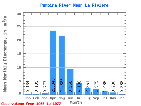
| Statistic | Jan | Feb | Mar | Apr | May | Jun | Jul | Aug | Sep | Oct | Nov | Dec | Annual |
|---|---|---|---|---|---|---|---|---|---|---|---|---|---|
| Mean | 0.13 | 0.20 | 0.73 | 23.35 | 21.59 | 9.27 | 4.14 | 2.35 | 1.98 | 1.48 | 0.78 | 0.29 | 5.80 |
| Standard Deviation | 0.16 | 0.46 | 0.94 | 28.89 | 20.77 | 9.37 | 3.82 | 1.82 | 2.48 | 2.31 | 0.99 | 0.35 | 4.83 |
| Min | 0.00 | 0.00 | 0.00 | 0.16 | 0.93 | 0.30 | 0.05 | 0.01 | 0.12 | 0.07 | 0.03 | 0.02 | 0.15 |
| Max | 0.52 | 1.74 | 2.92 | 89.10 | 76.40 | 35.60 | 13.60 | 6.48 | 10.20 | 9.47 | 4.00 | 1.23 | 16.50 |
| Coefficient of Variation | 1.16 | 2.36 | 1.30 | 1.24 | 0.96 | 1.01 | 0.92 | 0.78 | 1.26 | 1.56 | 1.27 | 1.22 | 0.83 |
 Return to R-Arctic Net Home Page