|
|
|||||||||||||||||
| Point ID: 2966 | Downloads | Plots | Site Data | Code: 05OB001 |
|
|
|||||||||||||||||
| Download | |
|---|---|
| Site Descriptor Information | Site Time Series Data |
| Link to all available data | |
| View: | Time Series | All |
| Units: | m3/s |
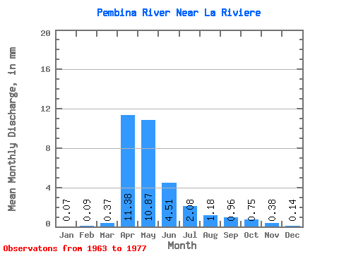
| Statistic | Jan | Feb | Mar | Apr | May | Jun | Jul | Aug | Sep | Oct | Nov | Dec | Annual |
|---|---|---|---|---|---|---|---|---|---|---|---|---|---|
| Mean | 0.07 | 0.09 | 0.37 | 11.38 | 10.87 | 4.51 | 2.08 | 1.18 | 0.96 | 0.75 | 0.38 | 0.14 | 34.41 |
| Standard Deviation | 0.08 | 0.21 | 0.47 | 14.08 | 10.46 | 4.57 | 1.92 | 0.92 | 1.21 | 1.17 | 0.48 | 0.18 | 28.62 |
| Min | 0.00 | 0.00 | 0.00 | 0.08 | 0.47 | 0.15 | 0.02 | 0.00 | 0.06 | 0.04 | 0.02 | 0.01 | 0.92 |
| Max | 0.26 | 0.80 | 1.47 | 43.41 | 38.46 | 17.34 | 6.85 | 3.26 | 4.97 | 4.77 | 1.95 | 0.62 | 97.85 |
| Coefficient of Variation | 1.16 | 2.36 | 1.30 | 1.24 | 0.96 | 1.01 | 0.92 | 0.78 | 1.26 | 1.56 | 1.27 | 1.22 | 0.83 |
 Return to R-Arctic Net Home Page