|
|
|||||||||||||||||
| Point ID: 2959 | Downloads | Plots | Site Data | Code: 05OA008 |
|
|
|||||||||||||||||
| Download | |
|---|---|
| Site Descriptor Information | Site Time Series Data |
| Link to all available data | |
| View: | Time Series | All |
| Units: | mm |
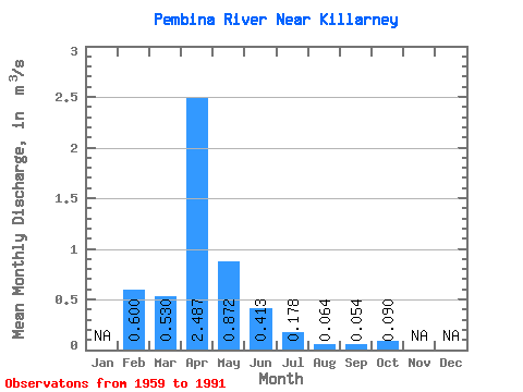
| Statistic | Jan | Feb | Mar | Apr | May | Jun | Jul | Aug | Sep | Oct | Nov | Dec | Annual |
|---|---|---|---|---|---|---|---|---|---|---|---|---|---|
| Mean | 0.60 | 0.53 | 2.49 | 0.87 | 0.41 | 0.18 | 0.06 | 0.05 | 0.09 | ||||
| Standard Deviation | 0.80 | 3.17 | 1.10 | 0.55 | 0.39 | 0.11 | 0.15 | 0.22 | |||||
| Min | 0.60 | 0.00 | 0.11 | 0.01 | 0.00 | 0.00 | 0.00 | 0.00 | 0.00 | ||||
| Max | 0.60 | 3.06 | 12.10 | 4.91 | 2.51 | 2.00 | 0.49 | 0.74 | 0.92 | ||||
| Coefficient of Variation | 1.50 | 1.27 | 1.26 | 1.34 | 2.18 | 1.72 | 2.79 | 2.44 |
 Return to R-Arctic Net Home Page