|
|
|||||||||||||||||
| Point ID: 2959 | Downloads | Plots | Site Data | Code: 05OA008 |
|
|
|||||||||||||||||
| Download | |
|---|---|
| Site Descriptor Information | Site Time Series Data |
| Link to all available data | |
| View: | Time Series | All |
| Units: | m3/s |
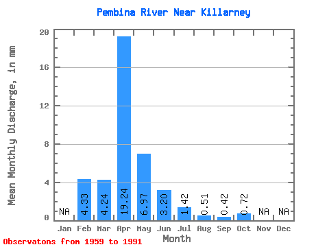
| Statistic | Jan | Feb | Mar | Apr | May | Jun | Jul | Aug | Sep | Oct | Nov | Dec | Annual |
|---|---|---|---|---|---|---|---|---|---|---|---|---|---|
| Mean | 4.37 | 4.24 | 19.24 | 6.97 | 3.20 | 1.43 | 0.51 | 0.41 | 0.72 | ||||
| Standard Deviation | 6.37 | 24.50 | 8.77 | 4.27 | 3.11 | 0.88 | 1.16 | 1.76 | |||||
| Min | 4.37 | 0.00 | 0.87 | 0.06 | 0.00 | 0.00 | 0.00 | 0.00 | 0.00 | ||||
| Max | 4.37 | 24.46 | 93.62 | 39.25 | 19.42 | 15.99 | 3.93 | 5.71 | 7.38 | ||||
| Coefficient of Variation | 1.50 | 1.27 | 1.26 | 1.34 | 2.18 | 1.72 | 2.79 | 2.44 |
 Return to R-Arctic Net Home Page