|
|
|||||||||||||||||
| Point ID: 2958 | Downloads | Plots | Site Data | Code: 05OA007 |
|
|
|||||||||||||||||
| Download | |
|---|---|
| Site Descriptor Information | Site Time Series Data |
| Link to all available data | |
| View: | Time Series | All |
| Units: | mm |
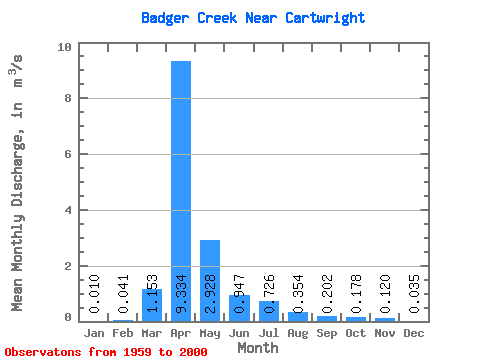
| Statistic | Jan | Feb | Mar | Apr | May | Jun | Jul | Aug | Sep | Oct | Nov | Dec | Annual |
|---|---|---|---|---|---|---|---|---|---|---|---|---|---|
| Mean | 0.01 | 0.04 | 1.15 | 9.33 | 2.93 | 0.95 | 0.73 | 0.35 | 0.20 | 0.18 | 0.12 | 0.04 | 1.23 |
| Standard Deviation | 0.02 | 0.18 | 2.19 | 12.08 | 4.66 | 1.27 | 1.68 | 0.72 | 0.57 | 0.42 | 0.23 | 0.06 | 1.34 |
| Min | 0.00 | 0.00 | 0.00 | 0.06 | 0.00 | 0.00 | 0.00 | 0.00 | 0.00 | 0.00 | 0.00 | 0.00 | 0.01 |
| Max | 0.07 | 0.90 | 8.22 | 40.40 | 22.10 | 5.58 | 9.59 | 3.60 | 3.37 | 2.54 | 0.89 | 0.20 | 5.26 |
| Coefficient of Variation | 1.57 | 4.34 | 1.89 | 1.29 | 1.59 | 1.34 | 2.32 | 2.04 | 2.83 | 2.36 | 1.89 | 1.62 | 1.10 |
 Return to R-Arctic Net Home Page