|
|
|||||||||||||||||
| Point ID: 2958 | Downloads | Plots | Site Data | Code: 05OA007 |
|
|
|||||||||||||||||
| Download | |
|---|---|
| Site Descriptor Information | Site Time Series Data |
| Link to all available data | |
| View: | Time Series | All |
| Units: | m3/s |
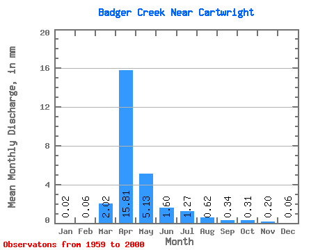
| Statistic | Jan | Feb | Mar | Apr | May | Jun | Jul | Aug | Sep | Oct | Nov | Dec | Annual |
|---|---|---|---|---|---|---|---|---|---|---|---|---|---|
| Mean | 0.02 | 0.07 | 2.02 | 15.81 | 5.12 | 1.60 | 1.27 | 0.62 | 0.34 | 0.31 | 0.20 | 0.06 | 25.31 |
| Standard Deviation | 0.03 | 0.28 | 3.82 | 20.46 | 8.16 | 2.15 | 2.95 | 1.26 | 0.97 | 0.74 | 0.38 | 0.10 | 27.75 |
| Min | 0.00 | 0.00 | 0.00 | 0.10 | 0.00 | 0.00 | 0.00 | 0.00 | 0.00 | 0.00 | 0.00 | 0.00 | 0.23 |
| Max | 0.12 | 1.43 | 14.39 | 68.44 | 38.68 | 9.45 | 16.79 | 6.30 | 5.71 | 4.45 | 1.51 | 0.35 | 108.61 |
| Coefficient of Variation | 1.57 | 4.34 | 1.89 | 1.29 | 1.59 | 1.34 | 2.32 | 2.04 | 2.83 | 2.36 | 1.89 | 1.62 | 1.10 |
 Return to R-Arctic Net Home Page