|
|
|||||||||||||||||
| Point ID: 2952 | Downloads | Plots | Site Data | Code: 05NG027 |
|
|
|||||||||||||||||
| Download | |
|---|---|
| Site Descriptor Information | Site Time Series Data |
| Link to all available data | |
| View: | Time Series | All |
| Units: | mm |
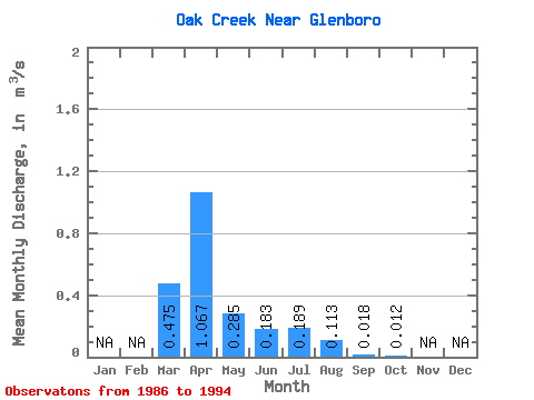
| Statistic | Jan | Feb | Mar | Apr | May | Jun | Jul | Aug | Sep | Oct | Nov | Dec | Annual |
|---|---|---|---|---|---|---|---|---|---|---|---|---|---|
| Mean | 0.47 | 1.07 | 0.28 | 0.18 | 0.19 | 0.11 | 0.02 | 0.01 | |||||
| Standard Deviation | 0.55 | 0.97 | 0.55 | 0.20 | 0.27 | 0.21 | 0.05 | 0.02 | |||||
| Min | 0.00 | 0.02 | 0.02 | 0.00 | 0.00 | 0.00 | 0.00 | 0.00 | |||||
| Max | 1.38 | 2.76 | 1.73 | 0.46 | 0.65 | 0.54 | 0.14 | 0.06 | |||||
| Coefficient of Variation | 1.15 | 0.91 | 1.93 | 1.09 | 1.40 | 1.84 | 2.69 | 1.84 |
 Return to R-Arctic Net Home Page