|
|
|||||||||||||||||
| Point ID: 2952 | Downloads | Plots | Site Data | Code: 05NG027 |
|
|
|||||||||||||||||
| Download | |
|---|---|
| Site Descriptor Information | Site Time Series Data |
| Link to all available data | |
| View: | Time Series | All |
| Units: | m3/s |
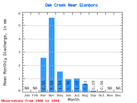
| Statistic | Jan | Feb | Mar | Apr | May | Jun | Jul | Aug | Sep | Oct | Nov | Dec | Annual |
|---|---|---|---|---|---|---|---|---|---|---|---|---|---|
| Mean | 2.56 | 5.57 | 1.54 | 0.95 | 1.02 | 0.61 | 0.09 | 0.07 | |||||
| Standard Deviation | 2.96 | 5.09 | 2.96 | 1.04 | 1.43 | 1.13 | 0.25 | 0.12 | |||||
| Min | 0.00 | 0.12 | 0.10 | 0.01 | 0.00 | 0.00 | 0.00 | 0.00 | |||||
| Max | 7.45 | 14.42 | 9.34 | 2.40 | 3.48 | 2.94 | 0.71 | 0.33 | |||||
| Coefficient of Variation | 1.15 | 0.91 | 1.93 | 1.09 | 1.40 | 1.84 | 2.69 | 1.84 |
 Return to R-Arctic Net Home Page