|
|
|||||||||||||||||
| Point ID: 2950 | Downloads | Plots | Site Data | Code: 05NG024 |
|
|
|||||||||||||||||
| Download | |
|---|---|
| Site Descriptor Information | Site Time Series Data |
| Link to all available data | |
| View: | Time Series | All |
| Units: | mm |
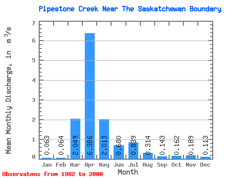
| Statistic | Jan | Feb | Mar | Apr | May | Jun | Jul | Aug | Sep | Oct | Nov | Dec | Annual |
|---|---|---|---|---|---|---|---|---|---|---|---|---|---|
| Mean | 0.06 | 0.06 | 2.05 | 6.39 | 2.01 | 0.68 | 0.84 | 0.31 | 0.14 | 0.16 | 0.19 | 0.11 | 1.08 |
| Standard Deviation | 0.09 | 0.09 | 2.47 | 7.47 | 2.48 | 0.98 | 1.49 | 0.51 | 0.15 | 0.14 | 0.28 | 0.14 | 0.98 |
| Min | 0.00 | 0.00 | 0.06 | 0.10 | 0.01 | 0.00 | 0.00 | 0.00 | 0.00 | 0.00 | 0.00 | 0.00 | 0.03 |
| Max | 0.21 | 0.28 | 6.44 | 25.00 | 8.39 | 3.20 | 5.72 | 1.64 | 0.44 | 0.48 | 0.90 | 0.39 | 3.22 |
| Coefficient of Variation | 1.35 | 1.37 | 1.21 | 1.17 | 1.23 | 1.44 | 1.77 | 1.62 | 1.05 | 0.90 | 1.48 | 1.27 | 0.90 |
 Return to R-Arctic Net Home Page