|
|
|||||||||||||||||
| Point ID: 2950 | Downloads | Plots | Site Data | Code: 05NG024 |
|
|
|||||||||||||||||
| Download | |
|---|---|
| Site Descriptor Information | Site Time Series Data |
| Link to all available data | |
| View: | Time Series | All |
| Units: | m3/s |
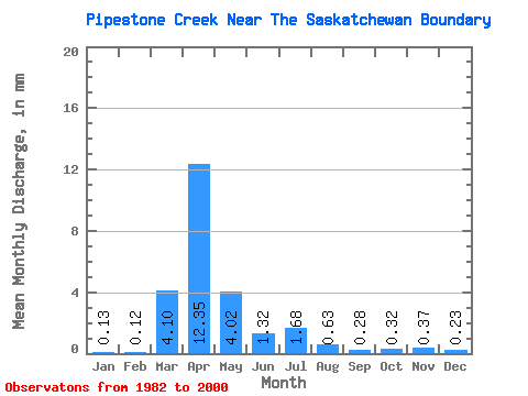
| Statistic | Jan | Feb | Mar | Apr | May | Jun | Jul | Aug | Sep | Oct | Nov | Dec | Annual |
|---|---|---|---|---|---|---|---|---|---|---|---|---|---|
| Mean | 0.04 | 0.04 | 1.42 | 4.29 | 1.40 | 0.46 | 0.58 | 0.22 | 0.10 | 0.11 | 0.13 | 0.08 | 8.87 |
| Standard Deviation | 0.06 | 0.06 | 1.71 | 5.02 | 1.72 | 0.66 | 1.03 | 0.35 | 0.10 | 0.10 | 0.19 | 0.10 | 8.02 |
| Min | 0.00 | 0.00 | 0.04 | 0.07 | 0.01 | 0.00 | 0.00 | 0.00 | 0.00 | 0.00 | 0.00 | 0.00 | 0.27 |
| Max | 0.14 | 0.18 | 4.47 | 16.79 | 5.82 | 2.15 | 3.97 | 1.14 | 0.29 | 0.33 | 0.61 | 0.27 | 26.30 |
| Coefficient of Variation | 1.35 | 1.37 | 1.21 | 1.17 | 1.23 | 1.44 | 1.77 | 1.62 | 1.05 | 0.90 | 1.48 | 1.27 | 0.90 |
 Return to R-Arctic Net Home Page